- Home
- Getting Started
- Documentation
- Release Notes
- Tour the Interface
- Tour the Layers
- JMARS Video Tutorials
- Lat/Lon Grid Layer
- Map Scalebar
- Nomenclature
- Crater Counting
- 3D
- Shape Layer
- Mosaics
- Map
- Advanced/Custom Maps
- Graphic/Numeric Maps
- Custom Map Sharing
- Stamp
- THEMIS
- MOC
- Viking
- CRISM Stamp Layer
- CTX
- HiRise
- HiRISE Anaglyph
- HiRISE DTM
- HRSC
- OMEGA
- Region of Interest
- TES
- THEMIS Planning
- Investigate Layer
- Landing Site Layer
- Tutorials
- Video Tutorials
- Displaying the Main View in 3D
- Finding THEMIS Observation Opportunities
- Submitting a THEMIS Region of Interest
- Loading a Custom Map
- Viewing TES Data in JMARS
- Using the Shape Layer
- Shape Layer: Intersect, Merge, and Subtract polygons from each other
- Shape Layer: Ellipse Drawing
- Shape Layer: Selecting a non-default column for circle-radius
- Shape Layer: Selecting a non-default column for fill-color
- Shape Layer: Add a Map Sampling Column
- Shape Layer: Adding a new color column based on the values of a radius column
- Shape Layer: Using Expressions
- Using JMARS for MSIP
- Introduction to SHARAD Radargrams
- Creating Numeric Maps
- Proxy/Firewall
- JMARS Shortcut Keys
- JMARS Data Submission
- FAQ
- Open Source
- References
- Social Media
- Podcasts/Demos
- Download JMARS
Release JMARS 5.4.0: Explore with Precision - Introducing Ellipse Drawing & Enhanced Profiling
In JMARS 5.4.0, we introduce two much-awaited updates: Ellipse Drawing (and Editing) and Enhanced Profiling
Ellipse Drawing & Editing
- Seamlessly draw ellipses with a simple click-and-move option
- Customize ellipses effortlessly with editable fields including major axis, minor axis, rotation angle, center longitude/latitude, mean axis, and aspect ratio
- Opt for circular ellipses with ease, simplifying your geometric creations
- Convert existing circles into ellipses
- Ellipses can be converted to circular ellipses
- Experience intuitive editing capabilities using mouse or keystrokes, empowering you to refine your designs with precision
Note: Optimal results are achieved when drawing features near the center of projection. Features, particularly those drawn far from the center, may exhibit distortion not apparent during the drawing process.

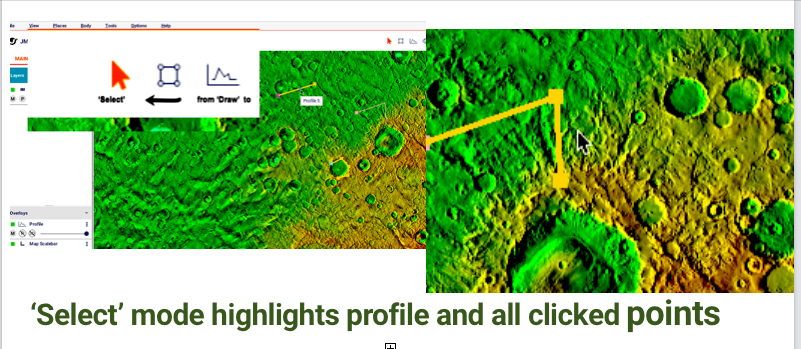
Enhanced Profiling
- Introducing 'Select' mode, mirroring the familiar selection process across JMARS layers for a seamless workflow
- Improved visual feedback during 'Draw' mode with outlined clicked points
- Identify starting points with visual markers for enhanced clarity in your profiles
- Select and unselect profiles with highlighted outlines, ensuring easy identification and management
- Utilize the 'Edit Point' and 'Reverse Profile' features for accurate adjustments and updates across all relevant views
- Export polylines from the Custom Shape layer to the Profile layer, fulfilling user requests for efficient polyline retracing
- Access start and end points in the Profile Manager, with the added capability to copy all profile points to the clipboard for detailed analysis
- Effortlessly locate profiles in the Main view with the 'Center on Profile' feature, ensuring quick access to profiles on a map