For further quantitative analysis of these maps, we recommend JMars.
Global Data Sets |
|||||||||||||

|
THEMIS Day IR 100m Global Mosaic
Daytime thermal infrared (12.57µm) mosaic. 593 ppd/100m.Interactive Map | Download Data |
||||||||||||

|
THEMIS Night IR 100m Global Mosaic
Nighttime thermal infrared (12.57µm) mosaic. 593 ppd/100m.Interactive Map | Download Data |
||||||||||||

|
THEMIS Day IR Global Mosaic
Daytime thermal infrared (12.57µm) mosaic. 256 ppd/230m.Interactive Map | Download Data |
||||||||||||
|
THEMIS Night IR Global Mosaic
Nighttime thermal infrared (12.57µm) mosaic. 256 ppd/230m.Interactive Map | Download Data |
||||||||||||

|
MOLA Shaded Relief / Colorized Elevation
Shaded relief derived from altimetry, colorized by elevation. 128 ppd/460m.Interactive Map | Download Data |
||||||||||||

|
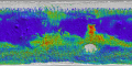
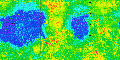
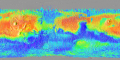
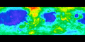
TES Thermal Inertia (Christensen et al.)
Colorized thermal inertia from NASA MGS/TES. 8 ppd/7.5km.Interactive Map | Download Data |
||||||||||||

|
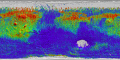
TES Thermal Inertia Nighttime 2005 (Putzig et al.)
Colorized thermal inertia from NASA MGS/TES. 20 ppd/3km.Interactive Map | Download Data |
||||||||||||
|
TES Thermal Inertia Nightside 2007 (Putzig & Mellon)
Colorized thermal inertia from NASA MGS/TES. 20 ppd/3km.Interactive Map | Download Data |
||||||||||||

|
TES Thermal Inertia Dayside 2007 (Putzig & Mellon)
Colorized thermal inertia from NASA MGS/TES. 20 ppd/3km.Interactive Map | Download Data |
||||||||||||
|
TES Albedo
Surface albedo from NASA MGS/TES. 8 ppd/7.5km.Interactive Map | Download Data |
||||||||||||
|
TES Dust Cover Index
Colorized surface dust cover index from NASA MGS/TES. 16ppd/3.5km.Download Data |
||||||||||||

|
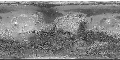
Viking Merged Color Mosaic
Viking color mosaic sharpened with MDIM 1.0. 64ppd/920m.Download Data |
||||||||||||
|
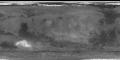
MOC Atlas
Mosaic of visible light, wide angle images. NASA MGS/MOC. 256 ppd/230m.Interactive Map | Download Data |
||||||||||||

|
MOLA Shaded Relief
Shaded relief derived from altimetry. 64 ppd/920m.Interactive Map | Download Data |
||||||||||||

|
MOLA Vertical Roughness
Red, green and blue composite from roughness at 0.6 km, 2.4 km, and 9.2 km baselines. 8 ppd/7.5kmInteractive Map | Download Data |
||||||||||||
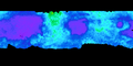
TES Mineral Maps |
|||||||||||||
| TES Mineral Maps: Colorized mineral abundance, NASA MGS/TES. 4 ppd/16km. | |||||||||||||
|
|||||||||||||
Viking IRTM |
|||||||||||||

|
Viking IRTM Albedo
Lambert Albedo, NASA Viking IRTM. 1 ppd/60kmInteractive Map | Download Data |
||||||||||||

|
Viking IRTM Rock abundance map
Colorized abundance of rocks bigger than 15cm, NASA Viking IRTM. 1 ppd/60kmInteractive Map | Download Data |
||||||||||||
|
Viking IRTM Thermal inertia
Colorized thermal inertia, NASA Viking IRTM. 0.5 ppd/120km.Interactive Map | Download Data |
||||||||||||
|
Viking IRTM Fine component thermal inertia
Colorized thermal inertia for particles smaller than 40 micrometers, NASA Viking IRTM. 1 ppd/60km.Interactive Map | Download Data |
||||||||||||

|
Viking IRTM 'High resolution' thermal inertia
Colorized thermal inertia, NASA Viking IRTM. 2 ppd/30km.Interactive Map | Download Data |
||||||||||||